|
Welcome to the Hay Historical Society web-site newsletter No. 9. Included in the newsletter is:
H AY S ESQUICENTENARY W EB-LOG. – The main additions to the Hay Historical Society web-site have been the monthly updates to the Hay Sesquicentenary Web-log [ link]. The last up-date was December 1858, with District Surveyor Adams continuing with the task of laying out a township at Lang's Crossing-place. It is planned to continue these postings for another year (to December 2009). This will carry the story to the first land-sale at Hay and a few months beyond. Since beginning the Hay Sesquicentenary Web-log I have became aware of other historical blogs on the Internet. For example the diaries of George Orwell from 1938 to 1942 are being published as a blog, with the entries appearing 70 years (to the day) since Orwell wrote them. The blog is published by the Orwell Prize and can be found at www.orwelldiaries.wordpress.comAnother highly-recommended blog which deals with historical matters is "Locust St." ( http://inkhornterm.blogspot.com/), which has high-quality postings about the history of American popular culture.
MACKENZIE'S RIVERINA (S ECOND E DITION). – The Hay Historical Society has published a second edition of the collected writings of Harold Mackenzie, Mackenzie's Riverina: A Tour of the Hay District Pastoral Holdings of the 1890s. The original 2002 publication sold out within a few months following unprecedented demand. This new edition contains an additional pictorial supplement featuring photographs which have been sourced since the original edition was published. For further details refer to this link.
B ACKGROUND TO THE 'S HEARING T ROUBLES'. – James Donaldson has kindly provided an article for the newsletter presenting a background to the 'shearing troubles' of the early to mid-1890s. His article has been edited into two parts, with the first part published in this newsletter. James is the author of the book, Shears, Sheds & Strikes: Australian Sheep Shearing in the Golden days of Wool, 1860-1890. Further details of James Donaldson's book can be found in Newsletter VIII (April 2008).
RIVER CROSSINGS. – The feature article of this newsletter investigates the river crossings at Lang's Crossing-place before Hay township was established. The article discusses the location where Henry Leonard operated his punt and also the precise location of the earlier river-crossing which became known as Lang's Crossing-place.
AN EARLIER MEANING OF 'OUTBACK'. – The editor of this newsletter has recently had an article published in Ozwords, the newsletter of the Australian National Dictionary Centre. The article is entitled 'An Early Meaning of "Out Back": Evidence from the Riverina Region of New South Wales'; it was published in the October 2008 edition of Ozwords. The article proposes and makes the case for an earlier meaning of the phrase 'out back', from which the modern word 'outback' derives. In its modern usage 'outback' describes and denotes remote and sparsely-populated parts of inland Australia (often used in a generic and romanticized sense). My article seeks to articulate an older meaning of the phrase 'out back'. My proposition is that during the mid- to late-nineteenth century 'out back' referred specifically to land away or distant from the frontages of permanent watercourses. Its usage can be associated with the historical pattern of European settlement on the saltbush plains of New South Wales. The case for an earlier meaning of the phrase 'out back' relies on the evidence of a batch of quotations, many of which pre-date the historical citations published in the Australian National Dictionary (published in 1988). The quotations were extracted from passages relating to the western Riverina region of New South Wales, obtained from newspapers, journals and government publications (the product of historical research undertaken by the Hay Historical Society).
Ozwords is published twice a year and is free to anybody who wishes to subscribe. The newsletter includes feature articles on Australian English by Australian National Dictionary Centre staff and guest contributors, as well as information on research, publications, and work in progress being undertaken by the Centre. If you would like to subscribe to Ozwords send your details to the Subscription Manager at Ozwords.au@oup.com ; the newsletter can either be posted or sent by electronic format to your e-mail address. Back-issues of Ozwords are available on-line at http://www.anu.edu.au/ANDC/pubs/ozwords/index.php
The classic reference on Australian English, The Australian National Dictionary (edited by William Ramson; Oxford University Press, 1988) has recently been made available on-line. The AND is a dictionary based on historical principals, aiming to provide as full an historical record as possible of Australian words and phrases.
The essence of an entry in an historical dictionary is its set of citations: these establish the chronology of a word's use, substantiate the definition or definitions, and illustrate the range of registers within which a word has been used. ['Introduction', The Australian National Dictionary]
Some Background to the 'Shearing Troubles' (part one)
James Donaldson
Introduction
This contribution to the Hay Historical Society's Newsletter comes as a response to the fine feature article, 'The 1894 Shearers' Strike: The 'Hay Riot' and Its Aftermath' written by Ian Beissel, which focused upon the particular 'shearing troubles' in the Hay district in 1894. These events were fully covered and highlighted in the April 2008 Newsletter. The theme of this paper will be the 'shearing troubles' in the years prior to 1894, which provide additional background materials, to assist an understanding of the pent-up emotions and lingering resentments that led to such events taking place in Hay in 1894.
Tensions in the Sheds
'Shearing troubles' had been a common feature of the annual wool-harvesting season for many a long day, involving as they did disputes and arguments between shearers and the owners of the sheep flocks. These 'troubles' derived from a wide variety of causes and included not only the daily working conditions and regulations within the woolshed itself, but also the station arrangements for accommodations and welfare during the actual time of shearing at the station. It was ultimately to be concerned, in the later years of the 1880s, with the more fundamental question of who was going to control the woolshed during the shearing.
The growth of the heavily capitalized and equipped pastoral sheep station over the years between 1860-1890, with its extension of sheep-carrying capacities, had made the pastoralists very powerful figures in the rural landscape. These 'sheep-' or 'wool-kings' become the landed aristocracy of pastoral Australia. The growth in pastoral investment during this period was phenomenal.
It transformed the social and economic status of the pastoralist and produced basic changes in personal relations and in estate management. Depending primarily on the laborious effort of large numbers of unskilled workers, the equipment of pastoral stations led eventually to a new pattern of labour relations in rural society. [N. G. Butlin, 'The Growth of Rural Capital, 1860-1890' (in) A. Barnard (ed.), The Simple Fleece: Studies in the Australian Wool Industry, Melbourne University Press, Melbourne, pp. 383-95 (quote from page 323)]
The pastoralists' attitudes and perspectives towards shearers became more difficult with the passing thirty years after 1860.
The operation of shearing sheep was done by contract; shearers were not paid a weekly wage, but every shearer contracted to shear at a pre-determined rate (usually per hundred sheep). Under contracting, the aim of the shearers was to shear as many sheep as possible. Most aimed at rapidity rather than at perfection. As a result the term 'tomahawking', or reckless shearing, came to be used, and tallies were often achieved at the expense of badly-cut or injured animals and improperly-shorn sheep. The sentiment is captured in the traditional shearing songs of the day:
But I'd rather tomahawk every day and shear a flock,
For that's the only way, I'll make some tin.
(and)
Tomorrow I'll go with a sardine blow,
for the century or the sack.
The cry of "tar, tar" was often more frequently heard than "wool, wool". Losses among sheep roughly-handled or badly-cut were common. Resentment against an unpopular shed manager could sometimes result in the shearer taking his bitterness out upon the sheep. Arguments regularly took place over the manner in which sheep were shorn, either because of damage to the fleece, caused by 'second cuts', or coming out of the wool, or breaking up the wool – or through rough treatment to the sheep itself, which caused gashes, excessive cuts or broken bones, or injury to ewes and rams through careless blades handling, or unsatisfactory shearing because of a shearer's urge for speed and larger tallies.
Station owners in the early 1870s tried to reform the ethos of fast rough shearing by offering prizes and certificates of efficiency to the shearers performing their task with care and proficiency. The inducement of prizes for good shearing failed, because after the first couple of days in a new shed, it was clearly obvious who was the best shearer. The ambition of those on the shearing board to become the fastest or 'ringer' shearer became a custom. Torn or broken fleece wools resulted in lower prices on the selling floor. To counter this practice, owners and station managers sought to place a daily limit on the number of sheep able to be shorn by a single shearer. With some shearers obviously more skilled and proficient than others the limitation upon tallies was unfair to the better shearers.
The following is from an article published in The Worker in 1836, written by an old shearer named Sullivan. The extract below relates his experience of shearing at the Riverina station of Urangeline in 1878:
In 1878 I said goodbye to the "Cabbage Garden" and crossed the border to New South Wales. My first shed was Urangeline, owned by the old miser, Bobby Rand. At this shed for the first time, I signed the old squatter's cast iron agreement of 17/6 per hundred. In the event of a man leaving or being discharged, he lost 2/6 per hundred.
The shearer provided his own rations also the provision of a cook. The cook received 2/6 per week from each man. My reign at Urangeline ended the second day. Bobby informed me that I was shearing too many sheep, so I left.
The historian Russel Ward summarised the paradoxical issues associated with shearing rates and the quality of workmanship that was demanded:
Most squatters attached more importance to speed than to painstakingly careful workmanship, but of course demanded both. And shearers despised a clumsy practitioner who cut or "haggled" his beasts, almost as much as they idolized the "gun" or champion for his record breaking tallies. [Russel Ward, The Australian Legend, Oxford University Press, page 173]
The common practice of 'raddling' a sheep with a coloured chalk crayon was a cause of antagonism and resentment. This was done by the owner or his representative as a means of indicating that the sheep had not been shorn to the satisfaction of the station, and the shearer's exertion in shearing these raddled sheep was not paid for in the day's tally. When it was wilfully done as a means of control, or as a way of saving money, it was a mean-minded action that did little to enhance the relationships between the shearers and their employers. Rather than speaking to the shearer early in the day, offering either criticism or correction, it was often at the end of a day's work that the manager indicated his displeasure. The practice of sacking a shearer some weeks after shearing had commenced, and then paying the discharged shearer at a lower rate than the agreed rate per hundred (even for those he had shorn prior to his dismissal), was also a common means of both saving money and exercising control over the nomadic workforce working on the board.
Disputes also arose between shearers and their employers over the inadequacy of the accommodations offered to them, or the washing facilities provided, or the quality of the rations, or the excessive prices that they paid for them, or for inferior brands of English blade shears provided by the station, or for the inadequate feed offered them for their horses in the paddocks. Old-hands were quick to seize any advantage that could be gained from inexperienced young overseers, acting as the boss of the board, and given the responsible task of managing the shearing operation.
Wages could also be a source of dispute, which could act as a touchstone enflaming a situation into something more threatening and explosive. The rising price of wool, or an increased number of wool bales being produced on the station, were never the reason for an increase in shearing rates, although a fall in the price of wool was sometimes stated as being the cause of lowered prices per hundred. Even when shearing became a harder and more demanding task in the later years of the nineteenth century – because sheep had become larger and carried an increased weight of fleece, and were better covered down the belly and legs – shearing prices were kept at the lowest possible level. Pastoralists could compensate for a rising rate of shearing by charging higher amounts for the mess rations, or overcharging the shearers for the provision of sheep shears. There was little individual shearers could do to alter the situation.
The Shearers' Agreement was an important document on a sheep-station during the shearing season, determining as it did the 'Rules and Regulations' under which the sheep would be sheared and the conditions under which the shearers would be employed. The contract itself was witnessed after the shearers had agreed to accept it. It then assumed legal authority and status under the law. Shearers' Agreements formalised the concept that the decision about what constituted a properly-shorn sheep lay solely with the pastoralist or his representative. The following document was signed by the shearers at "Steam Plains" station during the 1873 shearing season. "Steam Plains", situated between Deniliquin and Jerilderie in the southern Riverina, was an oblong block about fifteen miles long and five miles wide and consisted of open plains land intersected by sandy Murray pine ridges and belts of timber.
Agreement with Shearers
1873
Rules and Regulations to be observed in Steam Plains woolshed during shearing to commence about the twenty second of August 1873.
All sheep to be properly shorn and trimmed from nose to hoof to the satisfaction of the person in charge of the shed, and all dagging to be done before the sheep are counted out of the pens. The sheep to be cut as little as possible and when any sheep is cut the shearer shall call for tar.
All fleeces to be taken off the sheep without being broken more than is absolutely necessary.
Any sheep not shorn to the satisfaction of the person in charge of the shed will be raddled and not paid for.
Any shearer injuring sheep either wilfully or through carelessness shall pay for the same at the rate of ten shillings for each wether and eight shillings for each ewe etc. injured.
The person in charge of the shed may discharge any shearer who shall perform his work in a negligent slovenly or unworkmanlike manner or who shall misconduct himself in the shed or who shall disobey any lawful commands of the person in charge of the shed.
Each shearer shall be paid for each sheep shorn to the satisfaction of the person in charge of the shed, at the rate of seventeen shillings and sixpence per hundred sheep. If the person in charge of the shed shall have occasion to discharge any shearer, such shearer shall be paid for the sheep shorn by him at a rate of fourteen shillings per one hundred sheep.
No money will be paid to any shearer till all the sheep are shorn in the Steam Plain shed. All shearers to find themselves in rations. Work to commence at 6.00 a.m. Breakfast to be at 8.00 a.m. Work to commence after breakfast at 8.45 a.m. Dinner to be at 12 o'clock. Work to commence after dinner at 1 p.m. Ten minutes to be allowed for a smoke at 2.45 p.m. and 4.30 p.m. Work to be discontinued for the day at 6.00 p.m. A bell will ring for each of these Notices.
Rations will be supplied to the shearers at the Station Store at the following prices:–– Flour 50/- per bag, Tea 3/- per lb., Sugar 6d per lb., Shears 5/- per pair, Stones 3/- per lb., Oil 1/- per bottle, Tobacco 6/- per lb., Wethers 10/- each, Ewes 5/- each.
Names of shearers hired to do the shearing at Steam Plains according to the within mentioned Rules and name of Witness who heard the shearer engage to shear at Steam Plains according to the within mentioned Rules.
Shearers Witnesses Shearers Witnesses
John McGrath John Clark P. Tearnan
John West No. 1 T. S. Dodd
T. Dawson M. Healy
I. Melvin I. McFadden
I. Ball L. Flanagan
J. West No. 2 P. Page
M. McDermot Jas. Jackson
A. Jackson Wm Little
D. McLennan
A similar agreement to that of the "Steam Plains" Agreement, based upon one used on a sheep station in Victoria, was published two years later in the Otago Witness newspaper of 17 October 1875 where it was advocated as a "model" agreement. It took a later writer in the Otago Witness of 8 January 1876 to point out that such station shearing agreement documents almost wholly advantaged the interests of the proprietors and neglected the contracted shearers.
It has from time to time been suggested to draw out rules for the guidance and management of shearers, and fertile brains have occasionally put together a number of paragraphs, some of which are useful, while others are entirely absurd and objectionable. A specimen is at present going the rounds of the colonial press, and as on the whole has been favourably commented upon. It is objectionable, however, and but few shearers will be found willing to sign it. Its great fault is, as usual, the regulations are all in favour of the employer, while the shearer is in no way protected by them. The one in question contains eleven rules, and only one of these (regarding food) provides for the shearer.
Station Agreements were often the focus of shearing disputes. The agreements were a constant source of disagreement and woolshed disruptions, and became a focus of intense antagonism in later years, especially after the formation of the Union. The document, signed by each of the shearers and the station representative and carefully witnessed, as evidence of the transaction, was a legally binding contract, and shearers broke its clauses only at the peril of being taken to court and charged with failing to honour its contents. Fines or imprisonment were normally the result. Striking was not an option, as a failure to comply with the contract was punishable. Shearers were slow to realise that if they broke the contract, the Magistrate had no alternative but to apply the letter of the law. Thus individual shearers found it most difficult to oppose the management in control of the woolshed, and those who did so, were fined or jailed or were branded as hot-heads and trouble makers, finding it most difficult to gain work in other woolsheds. In those days shearers acting alone were in much the same position as individual stockmen and other station workers when they disagreed with the management. They were sacked and left without a recourse to any arbitration or alternative action.
W. G. Spence wrote about having a copy of a shearing agreement in his possession which was printed in large type and which was posted up in the woolshed at "Mount Eba" in South Australia in 1887. In writing of the harshness and unfairness of the regulations under which shearers worked, Spence made the following remarks.
The man in charge of the shed was sole judge of everything, and if a shearer was discharged he had to forfeit six day's shearing money and return shears and "any articles got from the store". Clause 6 reads, "Singing, whistling, swearing, and noise prohibited". The boss could sack a man when he liked, but unless the shearer went right through he forfeited his earnings. Clause 12 read: Payment to be made by money order drawn by the overseer on master, and payable in Adelaide.
As Spence concludes:
Just try and grip the unreasonableness of this clause. There was no payment at all until cut out, and then it was by money order payable in Adelaide, which in this case was only 750 miles away.
Another burning issue was that once shearers had signed the Station Agreement to shear, and they had commenced work, they were unable to leave the shed until the shearing was completed regardless of what the circumstances might be. If a shearer did leave the woolshed and went away, he could find that a warrant had been issued for his arrest. A Court would support the squatter and the shearer would have a conviction recorded against his name. Worse than that, the shearer might be placed in gaol as an example to others of the penalty of breaking his Agreement, and his wages for that shed, and for every sheep shorn by him, would be forfeited. The penalty for being discharged was that the shearer would be paid at a reduced rate for every sheep shorn until that time. One can imagine a mean-minded owner waiting until the end of the shearing was in sight, before discharging a shearer in order to save money. The shearer would be severely disadvantaged financially by such treatment. The owner also reserved the right that, if any shearer did not suit, not to discharge him, but also not to count his sheep. The shearer then could only leave the woolshed at the peril of an appearance in court. If sheep were 'raddled' (marked by the owner or shed-manager as being sheared in an unsatisfactory manner), then these sheep were neither counted, nor paid for at the end of the run. The control and authority lay squarely with the Station. Sackings were so common that shearers used to wait around outside the woolshed, even if they had not been engaged at the shed roll call at the commencement of the shearing. The shearing term, 'To wait for a death', had the meaning: 'to hang around a woolshed until someone is sacked so you can get a pen'.
In the days before the organization of the shearing workforce the station owners had no need to alter their Station Agreements to suit the needs of the shearers. If one group of shearers heard the Agreement read out to them and didn't like it, and refused to sign it, another group, perhaps tired of long journeying between sheds, or being ill-fed and hungry, would accept the station terms. As one correspondent wrote, "Once they put their name to it they have to submit as a child does to his teacher at school". This was simply because once the shearer put his name to the Agreement it became a contract that was legally binding upon him to abide by the clauses contained within it.
Stock Crossing-places and Punt Sites: River Crossings at Lang's Crossing-place
Ian Beissel
The frequent stock-crossings during the 1850s across the Murrumbidgee River at Lang's Crossing-place led directly to the establishment of Hay township by the end of the decade. The anonymous writer, calling himself 'Old Resident', made the following comments in 1883 regarding the genesis of Hay township:
It may not be generally known that the origin and rise of the town was solely owing to the immense overland traffic in sheep and cattle to Victoria, caused by the sudden increase of population on the various [gold] diggings during the early "Fifties," and consequent increased demand for animal food, which that colony was totally unable herself to meet. Mobs of ten, fifteen, and twenty thousand sheep and droves of one thousand, one thousand five hundred, and two thousand head of cattle were day after day wending their way from the north east down the Lachlan until they reached what is now Booligal, and then crossed the plain to the Murrumbidgee.[1]
With the approach of Hay's 150-year anniversary as a township this article seeks to critically investigate aspects of the locality prior to the establishment of the township, in particular looking at stock crossing-places and punt-sites in the vicinity of what was then known as Lang's Crossing-place.
There is a prevalent opinion that the original crossing-place for stock at Lang's Crossing-place was at the Bushy Bend Reserve, somewhere along the river from the north-east corner of the reserve to the vicinity of the present bridge. The following extract from the article 'History of the Settlement of the town of Hay, N.S.W.' is an example of this belief:
The site for the town of Hay was formerly known as Lang's crossing. (The actual ford was near "Bushy Bend").[2]
This commonly-held view is based on a reasonable premise. The nucleus of Hay township began on the high ground just to the north of Bushy Bend. Thomas Simpson's blacksmith shop and Henry Leonard's inn were established there and Leonard operated his punt at what is now the north-east corner of Bushy Bend Reserve. It seems reasonable to assume that Leonard had chosen to place his punt in close proximity to where stock was being crossed.
This article, however, puts forward a different viewpoint. Evidence is presented to support an alternate proposition that until the latter half of 1858 the main crossing-place – the actual Lang's crossing-place – was further downstream at the location known today as Sandy Point. The first punt at Lang's Crossing-place, belonging to the squatter C. N. Bagot, operated at Sandy Point across to the opposite bank. Bagot's punt operated for some two-and-a-half years, from mid-1856 to at least November 1858. There is strong evidence to suggest that Sandy Point was the main crossing-place for stock at the locality, at least until June 1858 when Henry Leonard began operating his punt at Bushy Bend. When Leonard's larger punt was launched the focus of operations in the river-bend changed from Sandy Point to Bushy Bend. However, it seems probable that crossings of stock, particularly cattle, continued to be carried out at Sandy Point during the early years of the township (probably until the bridge was opened in 1874).
This article also investigates the actual location where Henry Leonard operated his punt at Lang's Crossing-place from June 1858. The establishment of a punt by Leonard (in conjunction with an inn) was a key enterprise at Lang's Crossing-place. The reactions of district residents (both positive and negative) to Leonard's activities provided impetus for Government action which led to the establishment of Hay township. This article will seek to substantiate identification of the precise location where Henry Leonard's punt operated and determine whether physical evidence of the punt-site still exists.
Crossing-places
Many accounts of crossing-places on inland rivers describe the location as a ford (as in the extract previously quoted). Such a description suggests that the particular place was chosen because the river at that spot was shallow and firm enough to be crossed by wading or a dray could be driven from one side to the other. It seems obvious that when stock were crossing a river the animals would ideally be required to swim as little as possible. However, the inland rivers, in their unregulated state (as they were in the nineteenth century), were subject to great variability in water levels. This was particularly true of the Murrumbidgee River. Cattle, sheep and horses, as well as vehicles such as drays and carts, were crossed over the Murrumbidgee River under a variety of conditions, not just when the river was low. A spot on the river at a particular time might be fordable (or partially so) with a sluggish current; a month or so later the same location might have water at nearly bank level with a strong current (perhaps with overflow into a bend as well). The following example is indicative of this variability:
The Murrumbidgee commenced rising on the 26th June [1857], and has continued to come up with little intermission until the present moment; if it continues to rise at the same rate it will be bank high in about a week more. Many of the creeks are already much flooded, and it is generally thought that we shall have a heavy and long-protracted flood.[3]
Crossings were obviously more difficult and treacherous when the water-level was high and the current strong. More extreme flood conditions created an extra level of complication and danger to men and stock, often preventing the movement of stock altogether and frequently limiting or preventing the operation of punts (where they were available). The water-level was a variable over which the stockmen and squatters had no control, and crossings often needed to be made under difficult conditions. There were numerous places on the Murrumbidgee which were at least partially fordable during a low river, so it seems improbable that crossing-places were primarily chosen for their occasional fordability. It is more likely that other factors determined the choice of a particular site as a crossing-place.
|
An important (and perhaps self-evident) reason for a site to be chosen as a crossing-place was simply that it was near, or in the general direction of, the destination where the stock were being taken. Lang's Crossing-place was close to the home-station of the "Mungadal" run. The brothers Thomas, William and Gideon S. Lang had purchased the leasehold of the "Mungadal" run (originally called "Mungadingadel") in 1848 from John Tooth. "Mungadal" was the earliest and the most developed of the brothers' Murrumbidgee frontage runs. "Pevensey", further downstream, was purchased shortly after "Mungadal" (also from Tooth) and the "Eli Elwah" run (adjoining "Mungadal" upstream) was acquired during the mid-1850s. The Lang brothers had pioneered a route to their "Mungadal" run from 1851 when they began to overland cattle from Queensland to their Murrumbidgee frontage runs.
Another important factor in choosing a crossing-place was the gradient of the bank, both at the place where the animals entered the water and the likely place where they would reach the opposite bank (which might vary according to the prevailing strength of the current). A reasonably steady gradient was particularly important at the place where the stock emerged from the river, to ensure that the animals could do so quickly enough to prevent crowding of those following in the water. Congestion of the stock as they were crossing would increase the possibility that animals could be caught in the current and dispersed further downstream or possibly drowned. Relatively wide entrance and exit points with suitable gradients were ideal. Once a particular location began to be used as a crossing-place the abrasive action of thousands of hooves upon the river banks had a shaping effect on the bank structures, with a tendency to smooth rough edges and even-out the gradients between the river and surrounding plain. In this manner much-used crossing-places were shaped and became progressively more suited to their purpose.
Lang's Crossing-place also had an additional natural advantage in that the location was relatively accessible during flood events. This was probably due to the particular features of the surrounding topography; the configuration of creeks and other low-lying areas in the district and high-ground in the vicinity of the crossing-place allowed reasonable access to the crossing-place when the Murrumbidgee overflowed its banks. When the Murrumbidgee River flooded in October 1858 the Lower Murrumbidgee correspondent to the Sydney Morning Herald, George Boase [4], made these comments: It has long been almost universally admitted, that Lang's is the only really good spot on the Lower Murrumbidgee for a main crossing-place, although, up to the present moment, the Government have not taken any steps to accommodate the public by proclaiming it as a public thoroughfare. This flood has proved, more than ever, that Lang's is the place, as mobs of fat cattle and wool teams, after making vain efforts to cross the river at other spots lower down, have been forced to go there at last, as the only locality where a safe crossing-place could be found. [5]
|

|
Other nearby crossing-places did not have this advantage. For example, another crossing-place lower down the Murrumbidgee (at the future location of Maude), was practically inaccessible when the river flooded its banks. In April 1861, after the "new township named Maude" had been laid out, George Boase wrote about his misgivings for the future of the new settlement:
It is, however, very improbable that many buildings will ever be erected on the spot, as during a flood, or even when the river is very high, the spot can hardly be approached on account of the deep creeks which encircle it on both sides of the river. For about six months during last year the spot was isolated, and no one approached it unless obliged to do so by urgent necessity.[6]
Stock routes
Tracks developed to and from a particular crossing-place as it became regularly used. After a crossing-place had been chosen – for its location and as a place with banks allowing good access and exit for the stock – the crossing would become incorporated into the routes taken by stockmen. One of the popular inland stock-routes that was well-established by the mid-1850s crossed the Murrumbidgee River at Lang's Crossing-place. Stock movements at Lang's Crossing-place were primarily concerned with supply to the Victorian market in the wake of the gold-rushes which commenced in the early 1850s and the associated re-stocking of district runs. The Riverina, as the prime fattening country closest to Victoria, developed as a sort of holding centre, from where the Victorian market could be supplied with livestock as required. When local fat stock had been sold the pastoralists drew on breeding areas to the north and east (from the upper Darling, north of the Lachlan, the New England region and the hilly up-country to the east). A pattern developed whereby the Riverina runs became steadily de-stocked by the end of summer before the inward movement of stock began again in the autumn (or earlier if there had been good rainfall).
Stock travelling to the western Riverina from the north and north-west typically converged at Dubbo, then on to the Bogan River and across to the Lachlan River near Condobolin. The stock-route then followed the Lachlan to the vicinity of Lake Walgiers, before crossing the One-tree Plain to the Murrumbidgee River at Lang's Crossing-place. Stock travelling further south crossed the Old Man Plain for distribution to runs along the Billabong Creek, or on to Deniliquin for the Edward and Murray frontage runs. Stock being overlanded to Victoria from the western Riverina districts typically travelled to Maiden's Punt (Moama) where they crossed the Murray River.
The Lower Murrumbidgee correspondent to the Sydney Morning Herald, writing in 1858, was quite specific about the portion of the route between Lake Walgiers and Deniliquin:
On the existing route, which has now been used for about five years, the distances are as follows: – Higgins' station ["Ulonga"], on the Lachlan, to Cooladgerry, opposite to Lang's ["Mungadal" station], on the Murrumbidgee, 30 miles; Lang's to the Billabong, 42; thence to the Edwards River, 20, and 16 from thence to Deniliquin: total, 108 miles.[7]
The location "Cooladgerry, opposite to Lang's, on the Murrumbidgee" refers to the vicinity of Cooladgery Lagoon, at the eastern end of the "Wooloondool" run (leased at that stage by James McEvoy). The Cooladgery Lagoon is a long horseshoe-shaped billabong at the back of the place now known as Soapworks Bend, to the west of Hay.

There were various factors that might induce stockmen to depart from the Lachlan at Lake Walgiers and cut across the intervening plain to the Murrumbidgee River. It shortened the journey and the distance between water-sources was considered reasonable in normal seasons (except perhaps during the summer months) to enable stock to be safely driven. Also, as previously discussed, Lang's Crossing-place was the preferred place to cross on the lower Murrumbidgee when the river was flooded. In addition, the stock-routes both north and south of this crossing-place had already been established by the Lang brothers. The route south from the Murrumbidgee became known as Lang's Wool Road.
I am inclined to think that the reason of the traffic striking the river at this point [Lang's Crossing-place] was owing to the Messrs. Lang, of Mungadal, having cut a track across the plains with their wool drays, and which thirty years ago was known as "Lang's Wool Road."[8]
Bagot's punt
Where punts were unavailable, river-crossings of drays and carts in the sparsely settled inland districts usually entailed the lengthy and repetitious process of lashing empty casks to the vehicles in order to float them across. Cattle and horses could be swum across, usually without incident, but sheep would often be drowned during crossings. Punts at major crossing-places on inland rivers provided an opportune and valuable service and were lucrative businesses. Stockmen and owners found punts a great convenience for crossing vehicles and their teams, and they were often used for crossing sheep as well.
By early June 1856 Christopher N. Bagot, the squatter leasing "Illilawa" station, had began operating a punt at the location now known as Sandy Point (downstream from the present Hay Bridge). At that time Sandy Point was near the western boundary of the river frontage of "Illilawa" run and close to the boundary of James McEvoy's "Wooloondool" run. In the mid-1850s Sandy Point was known as Police Point, reflecting the fact that Bagot's "Illilawa" run was sometimes referred to as "Police Point" run.
The large number of cattle and sheep that annually cross the river at a spot known as Police Point (situated near the boundaries of the runs of Mr. Bagot and Mr. McEvoy, on the north side, and opposite to Mr. Lang's station on the south side, at a distance of 90 miles from Balranald, and 160 miles from Wagga Wagga), seems to have suggested to Mr. Bagot the propriety of establishing a punt on his run, close to the above-named spot.[9]
Bagot's punt crossed to the opposite bank just upstream of Bungah Creek. The vessel was described as "a small scow" (a flat-bottomed boat with square ends). Though not considered large it was nevertheless able to accommodate a dray and four bullocks, or two hundred sheep.
[Bagot's] punt is of moderate size, built in the ordinary manner, with moveable flats at each end. It is propelled by means of two ropes fixed from [each] bank, which ropes run through wooden blocks attached to the rails of the punt.[10]
The same report states that Bagot had begun to construct "yards and other conveniences" in conjunction with his working punt. His charges for crossing the river were: £3 for each thousand sheep; ten shillings for a bullock dray and team, or a horse and cart; and five shillings for a man and horse.
Opposition: Leonard's punt
By late 1857 Christopher Bagot had sold the "Illilawa" run to the squatter Henry Jeffreys, who continued to operate the punt at Sandy Point. It was still operating in January 1858 when William Henry Leonard – known as Henry Leonard – arrived at Lang's Crossing-place. Henry Leonard was often referred to as an "American", though he was actually from Studholm in New Brunswick, the south-east corner of Canada. Leonard was an experienced ship-builder who had supervised the construction of barges for Francis Cadell, a pioneer of steam navigation on the Murray River. Leonard recognised a business opportunity and had arrived at Lang's Crossing-place to undertake construction of a punt for use at the locality. Bagot's old punt at Lang's Crossing-place, now operated by Henry Jeffreys, was considered "to be too small for the proper accommodation of the numerous travelling parties who desire to cross the Murrumbidgee at that place"
Mr. Leonard, from the Murray, has just commenced constructing a punt, which, when finished, will be as large and afford as much accommodation as that now used at Maiden's [Moama]; the work is being rapidly proceeded with, and it will not therefore be long before the punt will be placed on the river, and although not intended nominally to supersede the existing punt, will in reality, from the superior accommodation it will afford, have the effect of diverting all the traffic from the present source.[11]
Leonard intended to supply the need for a larger punt at the site, with further plans to build a public house in conjunction with the punt.
Henry Leonard constructed his punt at Lang's Crossing-place up-stream of "the main crossing-place". It was reported in early June 1858 that Leonard's "new and commodious" punt had been launched, "and now requires but little additional labour for her completion".
She is to be floated down the river to the spot where the present small punt plies, at Lang's crossing-place, and will be placed there for the convenience of the public, who will, no doubt, find much greater facilities for crossing sheep than have ever yet been afforded on this part of the river.[12]
The above account, written by George Boase, contains a passage representing the central thesis of this article: "… the spot where the present small punt plies, at Lang's crossing-place…" Taken as a whole the sentence quoted above indicates that in June 1858 Boase believed that Henry Leonard intended to place his newly-built punt at "the spot" where Jeffreys' old punt was then operating (Sandy Point). An alternative interpretation is that Jeffreys had by that stage moved his punt to Bushy Bend, so "the spot" referred to in this sentence is about where Leonard eventually placed his punt. However, there is no evidence whatsoever to support the supposition that Jeffreys' punt had been moved. Less than a year beforehand C. N. Bagot had constructed "yards and other conveniences" at the site, so it seems highly improbable Henry Jeffreys would have abandoned these improvements and moved his punt to a new location. A description of the locality by George Boase (quoted later in this article) confirms that Jeffreys' punt was operating at Sandy Point as late as November 1858. 'Old Resident', writing in 1883, also makes the specific link between the site of Bagot's old punt and the crossing-place "known far and near as 'Lang's Crossing-place'":
There were then (I speak of before '58) no facilities for crossing the river, except a small scow which plied about opposite the present Black Horse Brewery, and I believe belonged to the manager of Illilawa, though it soon got to be known far and near as "Lang's Crossing Place." [13]
The Black Horse Brewery was built in 1878 at South Hay, opposite Sandy Point.
The following is an account by 'Old Resident' of Henry Leonard's initial efforts at Lang's Crossing-place:
That enterprising go-a-head American, the late Mr. Henry Leonard… in the early part of '58 laid the blocks to build the first punt, and shortly afterwards began to erect the first hotel in Hay…[14]
This passage suggests that Leonard constructed his punt near to where he erected his hotel. Henry Leonard probably always intended to locate his punt close to his hotel and George Boase's assumption, writing in June 1858, that Leonard would place it at the spot where the older punt operated was erroneous. Boase was based at "Gelam" station, about half-way between Lang's Crossing-place and Balranald, so it is likely much of his information about the doings at Lang's Crossing-place were received second-hand. There is no indication in Boase's accounts from this period that he was aware of the antagonism that existed between Leonard and Henry Jeffreys [15], which, in itself, was reason enough for Leonard to place his punt as close as possible to his hotel. 'Old Resident', who was living at Lang's Crossing-place during this period, was quite specific in describing the animosity that Henry Leonard encountered: I would remark that nine-tenths of the present inhabitants of Hay can form no idea of the difficulties and annoyances Mr. Leonard had to contend against in establishing a public crossing-place here; these were the days before "Free Selection," and the Crown tenants were most particular about any one trespassing on their holdings or runs… and as to putting up a building without permission nothing short of extinction was sufficient punishment for the offender.
Consequently this traffic had particularly irritated the owners and manager of the Woolloondool and Illilawa runs, and they were wroth at Mr. Leonard daring to settle down and erect buildings, etc., so they tried all they knew to stop the punt from being worked and the hotel being built. I expect it will be hardly credited these days that upon the completion of the punt and its being put into working order, the manager of the station came with the avowed intention of cutting the warp and letting the whole affair adrift, but Mr. Leonard was equal to the occasion and stood with a loaded gun and threatened to shoot the man that injured the rope.
I afterwards knew Mr. Leonard, and can safely say that he was just the man to carry out his threat; but happily it was not required, the other party apparently thinking better of it.[16]
In addition there was the incident in mid-July 1858 (by which time Leonard's punt was operating) when Leonard's partially-built hotel was deliberately damaged by the superintendent of "Illilawa":
Not so fortunate, however, was [Leonard] with the hotel, for Mr. Perston, manager for Mr. Henry Jeffrey, the then owner of Illilawa, actually brought down a team of bullocks, hitched them on to one of the verandah posts and pulled it out by the roots; thereby, I suppose, asserting his right to pull down all buildings erected on the run without his permission. I did not see this myself, but I heard Killeen, the driver of the bullocks, say that after fastening the chain to the post he threw down his whip and Mr. Perston had to start the bullocks himself.[17]
'Old Resident' proposes that the main reason for the antagonism directed at Henry Leonard by the squatters Jeffreys and McEvoy was that Leonard's hotel and punt encouraged trespassing across their runs. This may have been true of McEvoy in regard to the neighbouring "Wooloondool" run. For Jeffreys the enmity seems more likely to have derived from the fact that Leonard's punt was directing traffic away from his own punt. Henry Leonard's punt was in direct commercial opposition to Jeffreys' punt. This view is supported in a description of Lang's Crossing-place by George Boase in November 1858. He states that "for some time past no charges whatsoever have been made for crossing" on Jeffreys' punt.
The reason for this liberality on the part of the proprietor, is generally supposed to be a desire to oppose Mr. Leonard, whose house was pulled down some time ago, as it will be remembered, by Mr. Jeffreys' orders, who has a better punt a little higher up the river.[18]
Henry Jeffreys' hostility to Leonard's improvements at Lang's Crossing-place was in sharp contrast to his attitude to other building activities there just prior to Henry Leonard's arrival: the establishment by Thomas Simpson of a blacksmith's shop and Cadell's store on the road leading to the crossing-place.
Simpson and Cadell
A month before Leonard arrived at Lang's Crossing-place in January 1858 the blacksmith Thomas Simpson took up residence there. He had been invited to do so; in Simpson's words he was "induced at the request of several of the squatters and other settlers in the Murrumbidgee district". Simpson outlined the circumstances that led to him settling at Lang's Crossing-place in a letter he wrote to the Department of Lands in July 1867 supporting his application to purchase the land he had built his "improvements" upon.
In the month of December, 1857, I was induced at the request of several of the squatters and other settlers in the Murrumbidgee district to leave Deniliquin in order to commence my business as a blacksmith which was then much required in the district, and in that month I took up residence on the Murrumbidgee River on a portion of the run which then was the property of Mr. Jeffreys who gave me permission to occupy such land for the purposes of erecting a dwelling and shop, and under such circumstances I became the earliest settler at the place now known as the town of Hay, and one of the only persons who made anything like permanent improvements upon the land before the place became the site for a township… My establishing myself as a blacksmith at this place was… a matter of acknowledged public convenience, there being then no other blacksmith within a circuit of eighty miles from this town.[19]
Thomas Simpson erected a cottage and blacksmith's shop at Lang's Crossing-place. He chose a high spot on the eastern side of the river-bend (north of Bushy Bend), on a portion of the area which later became known as Wharf Reserve (in the vicinity of the present Hay Tennis Courts and nearby houses adjoining Bushy Bend).
At about the same time the steamboat-owner and entrepreneur, Francis Cadell, was preparing to establish a store at Lang's Crossing-place in order to position himself there in advance of the advent of steam-navigation on the Murrumbidgee. On 29 December 1857 (from Echuca on the Murray River) Captain Francis Cadell wrote to Major W. H. Christie, the Postmaster-General of the Colony of New South Wales. Cadell's purpose in corresponding with Major Christie was to recommend "the young Gentleman", Alexander C. Dunbar, to be appointed Postmaster at a "new Township to be formed" at the location described as "at the great 'crossing place' on the Murrumbidgee".
Mr. Dunbar is the Son of the late Professor Dunbar of the Edinburgh University and should any Certificates of character be required they can easily be furnished [by] Magistrates on the River to whom he is known.[20]
Cadell explained that Alexander Dunbar intended establishing a store at the crossing-place on the lower Murrumbidgee River.
In a later letter to Major Christie (dated 15 March 1858) Alexander Dunbar stated that he was established in a tent at Lang's Crossing-place and that the building of the store had been commenced.
At present I have only a Tent but I have a permanent building in the course of Erection which will be finished in the course of a Month or less.[21]
The site chosen for the store was on high ground north of Sandy Point on the boundary of the "Illilawa" and "Wooloondool" runs, near what is now known as Brewery Park (at the south end of Lindsay Street). Whether Francis Cadell had a direct financial interest in the store at Lang's Crossing-place at this stage is not known, though it is likely this was so. In any case it is clear that Dunbar and Cadell were close business affiliates. In the period of Dunbar's residence at Lang's Crossing-place the store was known as Messrs. Dunbar & Co., or Dunbar's Overlanders' Store. On early maps the building is marked as "Cadell's Store". In November 1858 the establishment was described as "two large slabbed buildings occupied as stores by Mr. F. Cadell" which were "standing by themselves" on the western side of the river-bend. [22]
Tracks and Surveys
In August 1958 District Surveyor Peter Francis Adams was instructed to lay out a township at Lang's Crossing-place as soon as it was practicable. Adams, who was based at Albury, arrived at Lang's Crossing-place in November 1858.
Mr. Adams… proceeded to Lang's, where he has since been employed in making a preliminary survey of the features of the ground and fixing upon the most suitable boundaries for a reserve.[23]
The layout of the settlement at Lang's Crossing-place when Surveyor Adams arrived in November 1858 was vividly described by George Boase:
On the north bank of the Murrumbidgee, at a spot about 150 miles below Wagga Wagga, and 100 above Balranald is a very deep bend of the river, the extreme bay of which consists of low swampy ground covered with stunted box trees, bushes, underwood, &c. Two thirds of the way up the bend commence a fine saltbush, thinly studded with gum trees, and with here and there a clump of mimosa. The mouth of the bend is about one-third or perhaps half a mile wide. At its western corner, and standing by themselves, are two large slabbed buildings occupied as stores by Mr. F. Cadell; at the eastern corner is seen a fine weather-boarded building, with a brick chimney, shingled roof, and wide verandah – near it is another slabbed building, and at a little distance a stable – over the door of the main building is a modest-looking sign, which informs the public that Henry Leonard is licensed to retail wine and spirits, at the sign of the Murrumbidgee Punt Hotel. Not far off are a saw-pit, a smithy, and several slabbed huts. A road running south from the hotel leads shortly to a large and commodious punt, where are conveniences for crossing sheep, drays, horses, &c.; the approaches to the punt lie high and above flood mark. From Cadell's store another road runs south-east to a smaller punt, the approaches to which are not very good, and are situated so low that during the recent flood they were under water, and were impossible for sheep or drays to approach the punt. This punt belongs to Mr. Jeffreys, and for some time past no charges whatsoever have been made for crossing in it. The reason for this liberality on the part of the proprietor, is generally supposed to be a desire to oppose Mr. Leonard, whose house was pulled down some time ago, as it will be remembered, by Mr. Jeffreys' orders, who has a better punt a little higher up the river. This, then, is the locality usually known as Lang's Crossing Place, the Overland Crossing Place, and Police Point. [24]
Surveyor Adams' decided to locate the streets and allotments of the proposed township on the eastern side of the river-bend, north of Leonard's and Simpson's existing buildings.
Several large mobs of cattle have lately crossed the river and have helped to make business a little lively. Mr. Adams has been continuing his survey of the locality, and it now appears that the greater part of the township will be above Leonard's Hotel, in fact his house will stand on almost the lower boundary line.[25]
As previously described, Cadell's store had been placed on the western side of the river-bend beside the track leading to the main crossing-place. By the time of Adams' visit it had became apparent that Cadell's store was situated on the opposite side of the river-bend from the focus of settlement activity at Lang's Crossing-place. The switch in importance to the eastern side of the river-bend had become a fait accompli even before Adams began his surveys, after the establishment of Leonard's punt and the opening of his hotel just to the north of Simpson's blacksmith-shop during the latter part of 1858. Surveyor Adams' plan for the new township gave official sanction to this development, entrenching the fact that the locus of settlement was in the proximity of the Murrumbidgee Punt Hotel. The placement of allotments on the eastern side of the river-bend also allowed access to the crossing-place for travelling stock, without the need to pass through the streets of the township. In January 1859, in response to commercial and practical reality, Cadell's store was moved to a location on the river bank between Leonard's hotel and Simpson's blacksmith-shop.
Cadell's large store formerly located some little way down the river at Cullageri, is now being moved on to the township, not far from the Hotel.[26]
This building became known as Cadell's Old Depot store.
At about the time of Cadell's store being relocated (or soon afterwards) District Surveyor Adams suffered "a severe attack of ophthalmia", which prevented him from continuing with his work at Lang's Crossing-place.
I am sorry to hear that Mr. Surveyor Adams has been prevented from plotting out the township, by a severe attack of ophthalmia, but will, as soon as sufficiently recovered, at once proceed with the work.[27]
Adams probably returned to Albury in February for medical treatment and to prepare his maps of Lang's Crossing-place and the immediate vicinity for sending to Sydney. He sent at least two maps to Sydney on this occasion, including his proposed plan for the "Town of Waradgery, Lachlan District". They were notated "Transmitted to the Surveyor General with my letter of 1st April 1859 – P. Francis Adams". The maps represent a cartographic snapshot of the locality, depicting the features of Lang's Crossing-place as it was prior to January 1859 (before Cadell's store was moved), showing buildings, punt-sites and tracks at the locality.
During the months following Surveyor Adams' return to Albury there was a hiatus in government action, with New South Wales elections being held in June and early July 1859. Despite the delay in marking out allotments to enable land-sales at Lang's Crossing-place reports indicate that the residents nevertheless continued with building activities at the locality.
Any person visiting the township and seeing various buildings in course of erection would be led to imagine that the allotments had been marked out and sold. Such is, however, I am sorry to say, not the case, and the public being unable to wait until the Government choose[s] to sell the land are obliged to erect their huts and stores, and run the risk of being put to the expense of having to remove them at some future time. The Survey Department has always been notoriously dilatory in its movements, and appears to be determined to keep up its character. May we hope that the new Parliament will cause more attention to be paid to the speedy putting up to auction of lands required by the public.[28]
In early August 1859 Assistant Surveyor Edward Twynam arrived at Lang's Crossing-place to complete Adams' work. Twynam had been appointed as an Assistant Surveyor in the New South Wales Survey Department on 11 March 1859.
Mr. Surveyor Twynam is engaged in laying out the Township [at Lang's Crossing-place], and not before the work is required. We may now expect, towards the close of the year, to see the land advertised.[29]
The work which Twynam undertook at Lang's Crossing-place included the preparation of allotments for sale which involved clearing street lines of scrub and small trees, marking trees on allotment lines with the distinctive 'horse-shoe' Surveyor's mark, digging trenches (called lockspits) on the corners of sections and allotments, and driving stakes at the corners of each section (branded with appropriate numbers). [30] In the meantime a map of the river-bend had been prepared by the New South Wales Survey Department, based on the maps sent by District Surveyor Adams in April, showing the features of the locality as they were prior to Cadell's store being relocated, as well as the proposed town allotments that were to be sold. A map, entitled 'Design for the Town of Hay in the Lachlan District, New South Wales, 1859', was laid before the Executive Council on 15 June 1859. The diagram below has been adapted from this map:

The map shows Cadell's store, as it was prior to January 1859, placed beside the track north of the crossing-place at Sandy Point. Just north of Cadell's store another track leads to the cluster of buildings on the eastern side of the river-bend belonging to Leonard and Simpson. This track appears to be a branch of the main track, facilitating access to Leonard's inn and punt. Opposite Leonard's punt this track loops back along the river-bank to rejoin the track south of Sandy Point. The directness of the track leading from Cooladgery to Bagot's punt supports the premise that this was the original route (that is, the track to the main crossing-place). The fact that the other track which crosses the river at Leonard's Punt loops back to rejoin the main track opposite Sandy Point leads to the conclusion that this was a later addition when Leonard's Punt began operating.
Vegetation densities
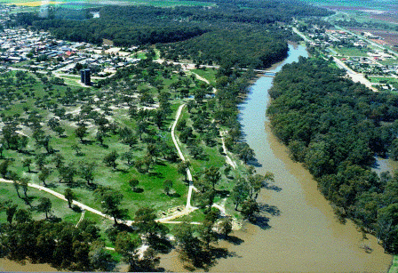
Nowadays Bushy Bend and Sandy Point are neatly divided by the southern end of Lachlan Street as it approaches the present-day bridge that was opened in June 1972. The two reserves have very different appearances. Sandy Point Reserve has an open aspect, consisting of scattered mature River Red Gum and Black Box trees with a dry grassy understorey. In comparison Bushy Bend is more thickly vegetated (as its name suggests); the mixed-age River Red Gums co-exist with a middle stratum of acacia species, growing in a sheltered and more humid environment. The vegetation density and profile of the Bushy Bend Reserve is more typical of the streamside vegetation of the lower Murrumbidgee River. In contrast, the Sandy Point Reserve is unusually open and dry.
| |
The aerial photograph (left), taken by Elizabeth Gibson in the 1990s, dramatically shows the differences, with Sandy Point in the foreground and Bushy Bend behind.
The open aspect of the Sandy Point Reserve with its relative lack of intervening shrubs and small trees can be explained by its regular use as a crossing-place since the early 1850s. In an article by the 'Lower Murrumbidgee' correspondent, George Boase, published in December 1856, the writer proposes that land to be surveyed for "a township on the Lower Murrumbidgee, somewhere near the spot where such large mobs of cattle and horses and such numerous flocks of sheep are almost continually crossing the river"; in discussing the need for common land in the vicinity of townships the writer observed that "such a commonage is more particularly necessary near a main crossing place, as the travelling stock render the sides of the main route perfectly bare and arid". [31]
|
The location of Leonard's punt-site
The punt at Bushy Bend operated under various owners for a period of about sixteen years from 1858 until at least 1874 (when the bridge over the Murrumbidgee at Hay was completed). During 1862 Henry Leonard's punt was subject to competition from William J. Disher who established a public house, punt and yards at Ecclesbank (located south of the present Hay cemetery about two kilometres upstream of the township). By February 1863, however, due to Disher's straitened financial circumstances, Leonard had purchased the Ecclesbank punt at public auction for £350.
The punt has since been removed down the river, and being placed at the end of Mr. Leonard's old punt forms a bridge now across the stream.[32]
In mid-year 1864 Henry Leonard established a punt service at Wentworth at the Darling-Murray junction (possibly using one of his punts re-located from Hay). [33]
Henry Leonard's punt at Hay was purchased by the New South Wales Government in the latter half of 1864 and proclaimed a public ferry. A scale of charges was published in the New South Wales Government Gazette on 28 October 1864. The tolls to be levied included twopence for each foot passenger, sixpence for each horse, one shilling for two-wheeled vehicles, one shilling and sixpence for four-wheeled vehicles and a halfpenny per head of sheep. There was an initial delay in finding a leaseholder for the government ferry as the fixed scale of charges were considered excessive by district residents. By early 1865 the Bushy Bend punt was being leased by Francis Calvert, a local businessman often described as an "auctioneer and commission agent". It was a profitable business for Calvert until early 1867 when his punt was subject to competition, once again from the upstream Ecclesbank location. Frank Johns, who had previously operated punts at Deniliquin and Maude, purchased Disher's Ecclesbank property and buildings and launched a new punt in conjunction with the hotel located there. A price war quickly developed when Johns halved his rates. By mid-April it was reported that Calvert's punt was operating without charge. [34] The intense competition between Johns and Calvert adversely affected the profits of both parties; in what appears to have been a compromise deal between the two businessmen it was announced in mid-September 1867 that Frank Johns had begun operating Calvert's punt at Bushy Bend (probably under a sub-leasing arrangement). [35]
When the lease of the Hay punt was auctioned in January 1869 Frank Calvert was once again the successful bidder (with Frank Johns probably continuing to sub-lease the punt from Calvert). [36] In August 1869, however, Frank Johns purchased Calvert's ferry business outright. Johns continued to operate the punt at Bushy Bend during the period of the construction of the Hay Bridge.
Tangible progress had begun in 1867 towards the construction of a bridge over the Murrumbidgee River at Hay. Money was voted for the project in 1868 by the New South Wales Government and a tender for its construction was accepted in January 1870. Iron-work from England began to arrive and was transported to the site during 1871. Construction of the bridge commenced in August 1871 and the approaches began to be formed from mid-year 1873. The renewal of the lease of the Hay punt was put up for auction at the Hay Court-house on 18 January 1872. The usual term for the lease of public ferries was of "one or more years, not exceeding three". On this occasion, however, due to the on-going construction of the Hay bridge and the uncertainty of its completion date, the government ferry at Hay was offered for a fixed term of only one year "or until the bridge was completed". The two interested parties (one of whom was Frank Johns) expressed a desire for a guaranteed two-year term. In the end both parties declined to lodge bids and the punt ceased to be a Government Ferry from the expiration of the lease on 1 February 1872. [37]
Frank Johns continued to operate a ferry service at Bushy Bend as a private business. The Hay Bridge was formally opened in August 1874. During the early years tolls were charged for use of the bridge, with the revenue going to the Hay Municipal Council. Frank Johns' punt continued to operate for some time after the bridge had opened, probably by the means of under-cutting the bridge toll charges.
The actual site where Henry Leonard established his punt in 1858 is apparent to this day. The location is where the one-way dirt road which loops through Bushy Bend first meets the river. Turning east off Lachlan Street the road initially follows a straight line, with a levee bank and the Gordon Tindale Memorial Park on the left; as it turns to the south-east, veering towards the river, a dip in the river-bank can be discerned (between the road and the river). This area, where Leonard and his successors operated their punts, is fairly open, with a picnic table in place.
The dip in the river-bank can be clearly seen in the following photograph, taken of this spot from the opposite bank of the river (a section of Hay State Forest).

Approaches to a working punt required a consistent and reasonably gentle slope to facilitate the loading and unloading of drays and other vehicles, as well as the orderly loading of sheep and other animals. There may have been a natural dip in the river bank at this place in any case. Behind this location, back from the river, is a shallow creek bed, which was probably why Leonard chose this specific spot. There is no doubt, however, that this dip has been considerably widened and modified during the years that the punt operated. In April 1863 it was recorded that there was an approach or 'gangway' cut into the clay bank, as well as a jetty, to enable loading and unloading of the punt. [38] In March 1867, during the price war between Calvert at Bushy Bend and Johns at Ecclesbank, it was reported that "the proprietors of both the punts are making great improvements in the gangways, &c., at their respective crossing-places by cutting them away and making them very easy for teams to pull up and go down". [39] In mid-August 1868 it was reported "that a road is being cleared from the ferry up into the township, that is from the punt gangway across that dangerous creek where teamsters have so often been stuck". The [part]ies who are doing this under the authority of our respected townsman, the Crown Lands bailiff, […] not gain anything by the use of the timber for [fire]wood, as considering that they are grubbing [out] the trees, and filling up the creek, making it a […]sable road, every pound's worth of firewood will doubtless cost them at least 25s. I hear it is contemplated to clear a road for teams, &c., on the other side of the river from the punt gangway to the main Government road right through the timber, [...] when done will be another great improvement.[40]
Conclusion
The details of the locations and means of crossing the Murrumbidgee River at Hay, as they evolved over time, is a vital consideration in the understanding of the early history of the township and an important aspect of the wider history of the Riverina pastoral districts. Nowadays the physical evidence of the crossing-places is not immediately apparent. However, a close study of historical sources, evidence from maps and a study of the landscape itself lead to the conclusions outlined in this article.
The primary purpose of this article is to investigate the locations of crossing-places and punt sites at the locality which was known (until 1859) as Lang's Crossing-place. The specific locations and their associated uses have been discussed in the context of their effect in determining the shape and manner in which the township developed. Lang's Crossing-place began as a stock crossing-place on a well-used stock-route. The added amenity of a punt – first Bagot's and then Leonard's – provided further stimulus for stockmen to cross the Murrumbidgee at that location. After the Government established reserves at the locality and surveyed the township, new residents began to arrive at the settlement. As the population increased those with capital or skills established businesses and others were attracted by the prospect of employment. As the township developed punts became the pre-eminent means of crossing the river (especially as the emphasis shifted on district pastoral runs during the 1860s from the fattening of cattle to wool-production). An essential amenity in any inland river-town is a safe and reliable means of crossing the river, able to be utilised in all but the most extreme circumstances. Fifteen years after the township was proclaimed, a bridge was finally opened at Hay, completing a process by which the residents of Hay might have justifiably claimed they were participating in 'the great project of civilisation' in a far-flung corner of the British Empire. The milestone was marked by the attendance of the Colonial Secretary, Henry Parkes, to perform the opening ceremony, the first occasion in which a minister of the colonial government visited the township.
The British historian, John B. Bury, writing in 1920 described the idea of progress as a "general article of faith" in Western culture.
The most striking advance has been in the technical conveniences of life – that is, in the control over natural forces. It would be superfluous to enumerate the discoveries and inventions since 1850 which have abridged space, economised time, eased bodily suffering, and reduced in some ways the friction of life, though they have increased it in others. This uninterrupted series of technical inventions, proceeding concurrently with immense enlargements of all branches of knowledge, has gradually accustomed the least speculative mind to the conception that civilisation is naturally progressive, and that continuous improvement is part of the order of things. [41]
Hay township was established at a spot on the Murrumbidgee River where stock were regularly being crossed and the settlement developed as a service hub for a large pastoral district. The successful establishment of a township on the edge of the vast saltbush plains was an apparent affirmation and embodiment of the Victorian concept of progress which stressed the growing power of man over the physical world and the improving, or "naturally progressive", character of human society.
[1] 'Recollections of Lang's Crossing-place (by an Old Resident.)', part I, Riverine Grazier, 12 December 1883.
[2] Mick Beckwith, 'History of the Settlement of the town of Hay, N.S.W.', Hay Historical Society Proceedings No. 5, 1985, pp. 6-11.
[3] Lower Murrumbidgee correspondent, Sydney Morning Herald, 4 August 1857.
[4] An important source of information about Lang's Crossing-place in the early years of settlement was a series of correspondent's reports from the 'Lower Murrumbidgee' published in the Sydney Morning Herald. The 'Lower Murrumbidgee' correspondent was George Boase, a native of county Devon in England. In August 1855 Boase obtained a position with the squatter Thomas D'Archy, as tutor to D'Archy's children at "Gelam" station (between Balranald and Lang's Crossing-place on the Murrumbidgee River). In 1856 he began submitting articles to the Sydney Morning Herald, which were published regularly under the title "Lower Murrumbidgee [from our correspondent]".
[5] 'Lower Murrumbidgee' correspondent, Sydney Morning Herald, 16 November 1858.
[6] 'Lower Murrumbidgee' correspondent, Sydney Morning Herald, 15 April 1861.
[7] 'Lower Murrumbidgee' correspondent, Sydney Morning Herald, 13 April 1858.
[8] 'Recollections of Lang's Crossing-place (by an Old Resident.)', part I, Riverine Grazier, 12 December 1883.
[9] 'Lower Murrumbidgee' correspondent, Sydney Morning Herald, 30 July 1856.
[10] 'Lower Murrumbidgee' correspondent, Sydney Morning Herald, 30 July 1856.
[11] 'Lower Murrumbidgee' correspondent, Sydney Morning Herald, 10 February 1858.
[12]'Lower Murrumbidgee' correspondent (report dated 12 June 1858), Sydney Morning Herald, 22 June 1858.
[13] 'Recollections of Lang's Crossing-place (by an Old Resident.)', part I, Riverine Grazier, 12 December 1883.
[14] 'Recollections of Lang's Crossing-place (by an Old Resident.)', part I, Riverine Grazier, Wednesday, 12 December 1883.
[15] George Boase probably became aware of the friction between the two men a month later; the hostility became manifest when Leonard's hotel was deliberately damaged, apparently by order of Henry Jeffreys.
[16] 'Recollections of Lang's Crossing-place (by an Old Resident.)', part I, Riverine Grazier, Wednesday, 12 December 1883.
[17] 'Recollections of Lang's Crossing-place (by an Old Resident.)', part I, Riverine Grazier, Wednesday, 12 December 1883.
[18] 'Lower Murrumbidgee' correspondent, report dated 27 November 1858, Sydney Morning Herald, 9 December 1858.
[19] Quoted in Riverine Grazier, 4 February 1955.
[20] Hay Post Office files, National Archives of Australia.
[22] 'Lower Murrumbidgee' correspondent, report dated 27 November 1858, Sydney Morning Herald, 9 December 1858.
[23] 'Lower Murrumbidgee' correspondent, Sydney Morning Herald, 21 December 1858.
[24] 'Lower Murrumbidgee' correspondent, report dated 27 November 1858, Sydney Morning Herald, 9 December 1858.
[25] 'Lang's Crossing Place' correspondent, report dated 11 December 1858, Wagga Wagga Express, 18 December 1858.
[26] 'Lang's Crossing Place' correspondent, report dated 22 January 1859, Wagga Wagga Express, 29 January 1859.
[27] 'Lang's Crossing Place' correspondent, report dated 12 February 1859, Wagga Wagga Express, 25 February 1859.
[28] 'Lang's Crossing Place' correspondent, report dated 12 February 1859, Wagga Wagga Express, 25 February 1859.
[29] Pastoral Times, 25 August 1859.
[30] 'Directions to be observed in marking Building and Suburban Allotments within Town Boundaries', Surveyor General's Office, 21 July 1858, New South Wales Votes and Proceedings of the Legislative Council, 1858, Vol. 2, pp. 649-656.
[31] 'Lower Murrumbidgee' correspondent, Sydney Morning Herald, 10 December 1856.
[32] Pastoral Times, 7 February 1863.
[33] Pastoral Times, 30 July 1864.
[34] Pastoral Times, 30 March 1867; 13 April 1867.
[35] Pastoral Times, 14 September 1867.
[36] Pastoral Times, 16 January 1869; 23 January 1869.
[37] Hay Standard, 24 January 1872.
[38] Pastoral Times, 11 April 1863.
[39] Pastoral Times, 23 March 1867.
[40] Pastoral Times, 22 August 1868.
[41] John B. Bury, The Idea of Progress: An Inquiry into Its Origin and Growth, Dover Publications, 1932 (first published in 1920), p. 332.
|
Previous newsletters can be accessed by clicking this link
Opinions and comment published in this newsletter reflect the views of the editor. Any corrections, contributions, further information or feedback (critical or otherwise) are welcomed.
© Copyright 2008,
Hay Historical Society Inc.
All rights reserved. The
material in this newsletter is
for personal use only.
Re-publication and
re-dissemination is expressly
prohibited without the prior
written consent of the Hay
Historical Society
Inc.
|
|